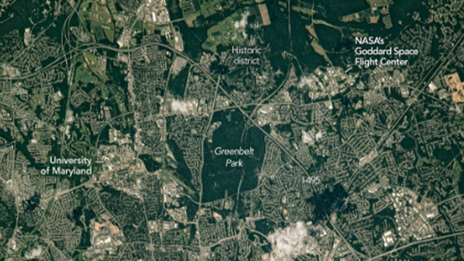
NASA’s “Belts of Green in the Washington Suburbs,” published as an Earth Observatory Image of the Day on April 22, 2026, is a small but useful land-use signal. The image shows the northeast side of the Capital Beltway in Maryland, where green spaces are woven through suburban development near Greenbelt. For SockoPower’s Chain category, the point is not spaceflight hardware. It is the way Earth observation helps identify how cities, parks, transport corridors, research campuses, and agricultural zones coexist inside a developed metropolitan region.
The photograph was taken from the International Space Station on July 30, 2023, using a 35mm camera, and NASA classifies the image under land use and urban development. That classification matters because the image is not merely scenic. It is a view of the built environment as an operating system: highways, neighborhoods, forested land, research facilities, campuses, and green corridors placed side by side.
The central location is Greenbelt, Maryland, on the northeast side of the Capital Beltway. NASA notes that the Beltway encircles Washington, D.C., and that numerous suburbs across Virginia and Maryland are accessible from it. The image captures the area where the Beltway passes through historic Greenbelt, a city whose original planning already connected housing, walking paths, shopping, and accessible green space.
One of the most visible green areas is Greenbelt Park. NASA describes the park as nearly 5 square kilometers, or about 2 square miles, with forested hiking trails, picnic areas, and a campground. The land was once intended as a future extension of the city of Greenbelt, but it was acquired by the National Park Service in 1950.
The image also contains a strategic institutional layer. East of the Beltway is NASA’s Goddard Space Flight Center, which NASA describes as its first spaceflight complex, established in Greenbelt on May 1, 1959. Around it are patches of forested land, while larger green areas to the north include forest and agricultural fields in Beltsville, including University of Maryland and USDA agricultural research sites.

That is the narrow Chain relevance. Green space here is not just decoration around suburbia. It is part of a regional pattern that includes transport infrastructure, federal research facilities, agricultural research, university activity, residential planning, and environmental buffer zones. From orbit, these elements appear as one connected landscape rather than separate policy categories.
The takeaway should be modest. This NASA image does not announce a new infrastructure program or a new industrial policy. It shows how astronaut photography can make the structure of a metropolitan chain visible: roads connect suburbs, research campuses anchor technical activity, green spaces buffer development, and agricultural sites preserve land-based research capacity near the national capital region.
For SockoPower, the value of this item is that it keeps Chain from becoming only a story about factories, ships, satellites, or supply routes. Physical land use also belongs to the chain. Parks, research campuses, green corridors, and agricultural test sites shape how metropolitan systems absorb growth, manage environmental pressure, and support long-term institutional capacity.
Why It Matters
This item matters because it shows how Earth observation can reveal the land-use structure behind urban resilience. NASA’s image of Greenbelt connects suburban development, transport infrastructure, federal research facilities, parks, and agricultural research sites into a single visible pattern. For Chain, the signal is that green infrastructure and research landscapes remain part of the operating base of a metropolitan system.
SockoPower Takeaway
The Greenbelt image is not a space technology story. It is a land-use signal. From the ISS, NASA shows how green space, research infrastructure, and suburban development share the same geography around the Capital Beltway. The strategic value lies in seeing urban growth and environmental buffers as parts of one regional chain.
What to Watch Next
Watch how NASA Earth Observatory images continue to document urban development, land-use pressure, and green infrastructure around major metropolitan regions.
Watch whether public agencies use satellite and astronaut photography more actively to communicate urban resilience, research geography, and environmental planning.
Watch how research campuses, agricultural fields, and green corridors remain embedded inside developed regions rather than pushed entirely outside them.
References
NASA Earth Observatory, “Belts of Green in the Washington Suburbs,” April 22, 2026.
Socko/Ghost